Mulu Pinnacles: Climbing to the iconic limestone karst landscape in Sarawak
- chasing peaks

- May 21
- 16 min read
15 June 2025

Elevation - 1,200 masl
Elevation gained - 1,200 m
Distance - 22.8 km
Total time taken - 3 days
Climbing period - March to September
Difficulty - 4/5 moderate (near vertical climbs with obstacles sections)
Trail type - Steep jungle terrains with various obstacles to navigate (eg. ladders, ropes)
Requirements - Sign up with a certified tour provider
The Mulu Pinnacles are a series of tall, razor-sharp limestone spires in Mulu National Park, Sarawak, Malaysia, famous for their spectacular views and challenging climb. The trek is a 3-day, 2-night trip that includes a 2 nights overnight stay at Camp 5, with a 2.4 km near-vertical climb to the viewpoint.
An interesting fact is that it is featured alongside Mount Kinabalu on the RM 100 note. Having already completed Mount Kinabalu, we knew we had to also complete this second iconic climb! I have always felt that I was not a 'fast hiker'; hence, I had reservations about attempting this climb, especially since there are strict cut-off timings for the summit push. Plus, the warnings in bold red highlighting the difficulty and danger of the climb on the registration page were another deterrent to scare off unprepared hikers. But if I never tried, I would never know, right?
Overview
Trip Planning
As usual, we wanted to go for the most cost-effective options, so we went online to compare the prices. We realised we could save a significant amount just by booking the individual tours and accomodations directly through the national park rather than going for the all-in commercial tours provided by agencies. The only downside was that we would have to settle our own food during the 3-day hike. We ended up just bringing a mix of convenience store sandwiches and ready-to-eat (RTE) meals to tide us through the 3 days. Another option was to cook our own meals since the kitchen facilities at the campsite are actually pretty good, but we were too lazy for that.
For accommodations, we booked our 2-night stay in Camp 5 as part of the hike itinerary, as well as 1-night accommodation in Mulu town for the night before the hike. The dates for the Mulu Pinnacles Hike are limited by the bed availability at Camp 5, so do secure your dates early to guarantee a spot. There are two main accommodation options in Mulu town: Mulu Park Longhouse and Marriott. Since we figured we would not be spending a lot of time at the accommodation, Mulu Park Longhouse was more than good enough for us. The accommodation was clean and comfortable, situated conveniently at the entrance of the national park (since all of the tours start from the entrance, this was definitely a plus point). But if you're into more of a luxury travel, Marriott is also a good option.
Other than the Mulu Pinnacles, the Mulu National Park is also well known for its show caves. So it is highly recommended that you give the show caves a visit as well! We put together an itinerary to optimise our visit to cover all the main attractions in Mulu National Park. We booked all our tours and accommodation directly from the national park. This is our itinerary for the 4 days we spent in Mulu:
Day 1 | [2.30pm] Deer and Lang Caves (with bat exodus) |
Day 2 | [9.15 am] Clearwater and Wind Caves Mulu Pinnacles Hike - to camp 5 |
Day 3 | Mulu Pinnacles Hike - to Pinnacles viewpoint |
Day 4 | Mulu Pinnacles Hike - back to park HQ |
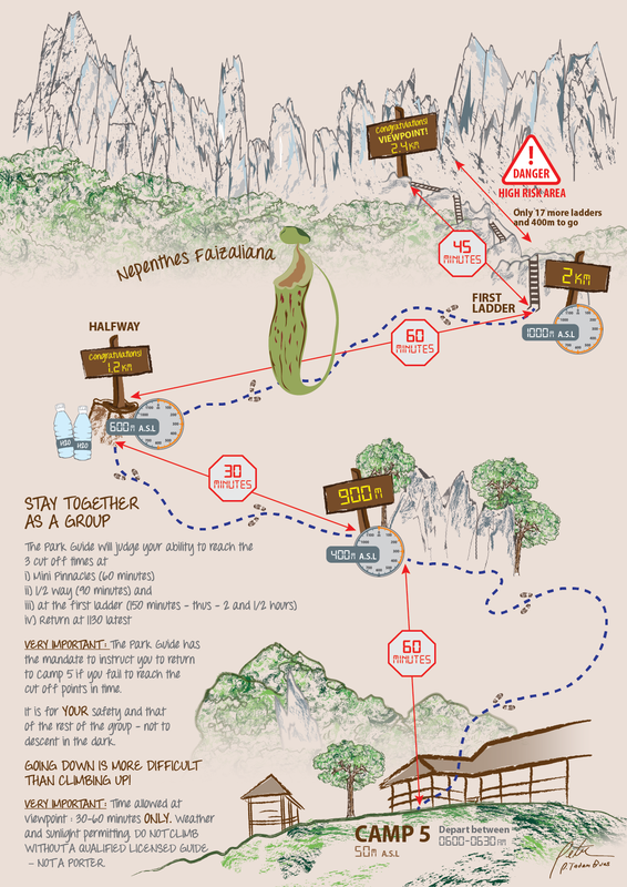
This is a useful map to reference the checkpoints for the Mulu Pinnacles hike and the cut-off timings. It is important that you reach the checkpoints before the cut-off time; otherwise, you will be made to turn back.
Costs
[Accommodation] Mulu Park Longhouse (includes set breakfast) | 362 RM (+ 10 RM tourism tax) price for chalet for 3 pax |
[Tour] Deer and Lang Caves | 35 RM |
[Tour] Clearwater and Wind Caves | 30 RM |
[Tour] Mulu Pinnacles 3 day Hike (includes guide, accommodation in Camp 5, boat right to and from trail head) | 455 RM |
[Fees] Park Entrance Fees | 30 RM |
Total | ~ 670 RM per pax |
cost indicated is per pax
Getting There
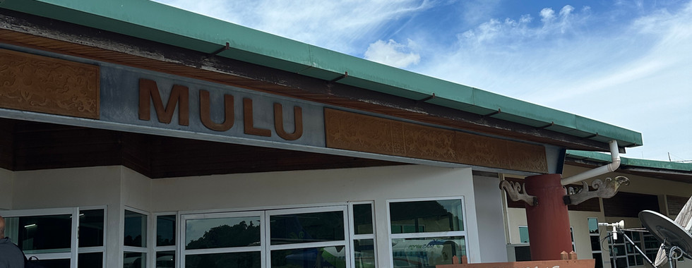
There are very limited flights to Mulu, and you can only fly in from Miri, Kuching, or Kinabalu. We transited in Kuching and took the early morning flight into Mulu so we could catch our 2:30 pm tour. It was quite an experience taking the special propeller plane on Malaysia Airlines's MS Wings into Mulu and landing in the middle of a vast jungle. Mulu Airport is one of the smallest I have seen, with only one plane on the tarmac (the one we came in) and only a single counter at the airport.
Day 1 - Deer and Lang Caves
1400 | Check-in to Mulu Park Longhouse |
1430 | Visit to Lang Cave |
1600 | Visit to Deer Cave |
1730 | Bat Exodus |


1400 | Check-in to Mulu Park Longhouse
After reaching Mulu via the exciting propeller plane ride, we got a car ride to the entrance of the national park. The town itself is pretty small, and you can easily get a ride from the airport to your accommodation for 5 RM, and it is only a 5-minute ride. We then paid for the park entrance fees and checked into our chalet at the Mulu Park Longhouse. The accommodation was clean and comfortable, and it is pretty cool to be staying right in the national park. Do note that they will give you a wristband to wear throughout your stay at Mulu, and you will not be allowed to remove it. Yes, you will have to bathe with it too!


1430 | Visit to Lang Cave
We grabbed a quick meal at the national park cafe before walking over to the meeting point for our first cave tour. One perk of staying at the national park is that you are already right at the tour meet-up points. I was quite surprised to see a pretty diverse group of participants from various nationalities. It was a long boardwalk to get to the caves, and since there were a number of groups, we had to wait for a while for our turn to access the caves.
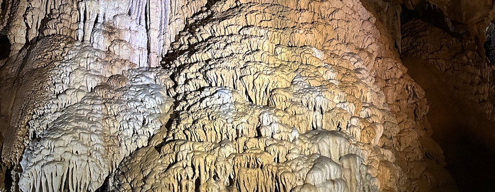
We headed into the smaller Lang Cave first. The cave was discovered in 1977 by a local Berawan man named Lang Belarek, hence the name Lang Cave. Though small in size, it is one of the most beautiful caves in Mulu with a variety of stalactites, stalagmites, and other cave formations. We learned that a lower cave ceiling meant that it was easier for the mineral-rich solutions to accumulate and form cave formations.
It was interesting to see a variety of cave formations, including the famed jellyfish formation and fan formation. We even spotted sticky worm threads hanging from the ceiling of the cave.


1600 | Visit to Deer Cave
We then headed to the second and much bigger cave, right around the corner. It's named the Deer Cave as there used to be deer in the cave. The deer would come here to consume salt from the cave, and guess where the salt is from? It is actually from the bat poop, also called guano. We could definitely smell the guano as we entered the cave...
Deer Cave is one of the widest caves in the world, with a ceiling height of 120m. I was in awe at how vast the space within the cave was. There were black patches along the ceiling of the cave, and we were told these were the local residences - 5 million bats live within this cave. It was a long walk to the other end of the cave, where it opens up to lush greenery - this spot was called the Garden of Eden.
We then hurried back out as we didn't want to miss the bat exodus.


1730 | Bat Exodus
Every evening, like clockwork, the bats would fly out of Deer Cave in flocks, though this sometimes does not happen if the weather is bad. We headed to the viewing platform, where everyone had already gathered to patiently wait for the bats to do their thing. Everyone was staring intently at the entrance of the cave for a sign of the bat exodus. After close to an hour's wait, some gave up and left to head back to the entrance.
Just as we were prepared to be disappointed as the sky was starting to get dark, a guide with a binoculars signalled that the bats had started to regroup. This was a sign that the bat exodus was starting. Soon, the first group flew out in a mesmerising spiralling flight pattern. Subsequent groups quickly followed and everyone kept absolutely silent to hear the flapping of the bats. It was pretty cool, nature's own show.
After the last of the bats had taken flight, we headed back to the park entrance for dinner and rest for the night.
Day 2 - Clear Water, Wind Caves, and the hike to Camp 5
0900 | Cave of the Winds |
1130 | Clear Water Cave |
1330 | Trek to Camp 5 |
1630 | Arrive at Camp 5 |
1800 | Dinner and Rest |


0900 | Cave of the Winds
The next morning was the official start of the 3-day hike to Mulu Pinnacles. But before that, we decided to add on 2 additional cave tours - Clearwater and Wind Caves. We got up early to have our breakfast at the cafe, then deposited our additional baggage near the entrance. At around 9 am, we gathered at the usual spot at the park entrance, before being loaded group by group into longboats. Unfortunately, it had been the dry season for the past couple of weeks, so they warned that if the water level was too low and the boat got stuck, we would need to help push it.
For the most part, it was a peaceful ride as the boatman skillfully guided the boat to avoid the rocky patches. We stopped at a small craft market briefly before continuing to the Wind Cave. The second half of the boat ride was less smooth, as our boatman had to get off repeatedly to push our boat whenever it got stuck. I'm surprised the boat didn't have a hole scraped open at the bottom from all that dragging. More than an hour later, we finally reached the entrance of the first cave—Wind Cave. The cave is named as such because of the airflow moving from a larger cave area through a smaller tunnel, resulting in a 'breeze' within the cave.


1130 | Clear Water Cave
We then headed a bit further along the river to the second cave entrance. There's a big picnic area where we had our packed lunch (bought from the park cafe in the morning). Right next to the picnic area is a lake with clear turquoise water. I think that's where it got the name Clearwater Cave? Of course, I could not resist jumping into the clear lake. The water was nice and cooling.
After lunch, we headed up the flight of stairs into the Clearwater Cave. The path led us into the caverns within the cave. After visiting so many caves the past few days, I was still in awe every time we stepped into a different one. Each one had its own distinct characteristics—this one had a clear water river cutting right through. We kept going upwards towards a huge opening with a stunning skylight, before looping back to the start, passing by various stalagmites and stalactites.


1330 | Trek to Camp 5
We headed back to our boat to continue to the starting point of the Mulu Pinnacles hike—finally! The boat ride took another hour as our poor boatman had to push the boat through rocky riverbeds. After docking along the rocky shore, we waded through the river towards the start of the trail. From here, it was a 9 km walk to reach Camp 5, where we would be staying for a night before the summit push tomorrow. Luckily, the trek to the camp was flat with clear trails, though it does get pretty monotonous after a while. We were always excited to spot the next distance marker, the only sign that we had passed another km. The highlight of this trail was the two hanging bridges to break the monotony. They were narrow and slightly shaky, quite fun.


1630 | Arrive at Camp 5
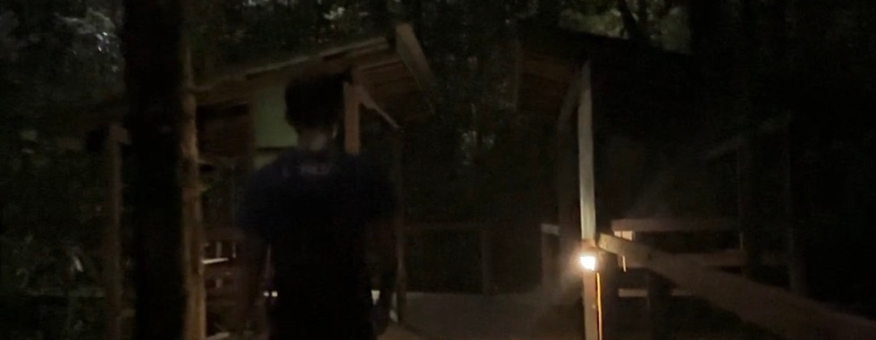
After close to 3 hours of hiking, we were excited to spot a clearing with some houses. The guide showed us to our designated sleeping area and facilities at Camp 5. We were provided with a sleeping pad and a mosquito net (you will need to rent and pay for this at the national park before the hike). After setting up our sleeping area, we went out to explore the campsite. Right next to the campsite is a tranquil river with mountains for a backdrop. Who would be able to resist going for a dip? Sitting in the clear and cooling river, looking out into the picturesque scenery of the mountains in the distance was honestly the best way to end a long day. It was kampong life at its best.
We then showered at the campsite toilet. The toilets were surprisingly clean and well-maintained, I would say the best I have seen at any campsite/mountain hut!
1800 | Dinner and Rest
Then we prepped our dinner. The kitchen was packed at this point, with guides busy running around cooking for their groups. Since we did not pay more to join a commercial tour, we had to settle our own meals during the 3 days of hiking.
We were too lazy to prepare an elaborate dinner, so we brought ready-to-eat meals from Kembara and cooked an egg to add on (eggs were bought at the national park cafe; they sell simple groceries there). The Kembara RTE meals were super simple to prep, just boil hot water, pour it into the packet, and wait for about 10 minutes for the food to heat up. I was eating the beef rendang rice that day, and it tasted surprisingly not bad. As we were eating, the sun started to set, lighting the sky up in a warm orange glow.
We packed the essentials for the summit push the next day and got an early night's sleep.
Day 3 - Climb to Mulu Pinnacles
0600 | Set Off |
0700 | Checkpoint 1 - Mini Pinnacles (900m) |
0745 | Checkpoint 2 - Halfway (1.2km) |
0900 | Checkpoint 3 - First Ladder (2km) |
1000 | Mulu Pinnacles |
1015 | Back Down the Ladders |
1200 | A Quick Lunch |
1300 | A Bad Fall |
1530 | Back to the Campsite |
1600 | River Dipping |


0600 | Set off
We were up bright and early, waiting for the first light to set off for Mulu Pinnacles. It was finally the day! I was honestly still quite nervous about not being able to make the cut-off time. But I was hyped up and was definitely going to give it my best shot.
All the hikers from our camp had gathered, and we set off into the forest.
0700 | Checkpoint 1 - Mini Pinnacles (900m)
After a short walk and a turn, the trail started to climb upwards, steeper and steeper. We paced ourselves as we made our way to the first checkpoint marker. About 45 minutes in, we spotted the first checkpoint marker, a sign we had made about 900m of the journey with 450m elevation gained. This checkpoint is named the mini pinnacles, as there were small pinnacles jutting from the ground. I was super happy that we were well within the cut-off time of 1 hour, a confidence boost for the next section. We took a short break, snapped a photo with the checkpoint marker, and continued to our next goal - checkpoint 2.


0745 | Checkpoint 2 - Halfway (1.2km)
Around 30 minutes into the grueling uphill climb, we spotted another marker, a sign that we had completed 1.2 km of the journey with a total of 645 m elevation gained. Together with us was around half of the group that had reached this point. This was halfway through the journey, and the guide said we could deposit some of our water at this point for the trip back down afterwards.
We took our second and last 'long' break of about 5 minutes before we continued to the next checkpoint.
0900 | Checkpoint 3 - First Ladder (2km)
It was another 1 hr of steep uphill climbing, and I was definitely feeling the fatigue at this point. For most of the hike up, we had to go on all fours, using both our hands and legs to haul ourselves up the rock faces. Around another 1 hr later, we spotted the first of the infamous 17 ladders, marking the next checkpoint. This was about 2 km into the journey, and 1000 m elevation gain. A sign marked the cut-off time for this checkpoint - 9:30 am.
The next section was going to be very different from the previous section we had climbed. It was a near-vertical climb for most parts, navigating a series of obstacle courses including climbing 17 ladders, hauling ourselves using ropes, walking on thin metal planks, all while teetering high above sharp rock edges. This was the section the bold red text in the pamphlets had warned hikers about; a small mistake could prove fatal, and rescue efforts would be costly. I knew I had to be extra focused for this section and not slip up. But all in all, this was very exciting, since I enjoyed the challenge of climbing obstacles hehe.


1000 | Mulu Pinnacles
I lost count of the number of ladders, ropes, planks, and obstacles we had to cross. We were just focused on what was in front of us. It started raining at this point, and the path became slippery, which made everything extra hazardous.
We climbed through the last series of huge boulders, turned a corner, and the iconic karst landscape of the Mulu Pinnacles came into view. The viewpoint was pretty small, so we had to perch on the rocks while waiting for our turn to take a photo in front of the pinnacles. And of course, I had prepared a 100 RM note for a photo with the actual pinnacles heheh.


1015 | Back Down the Ladders
We were probably at the viewpoint for less than 15 minutes before being instructed to quickly descend as the rain was starting to get heavier, also to make space for the hikers coming up. The guide also instructed us to inform any hikers coming up to turn back, as the weather was getting worse.
With the rain, the route down was even more treacherous and slippery than on our way up. We watched our every step and were extra careful so as not to fall to our deaths... With the rain, our progress down was a lot slower, and it took a whole 1.5 hours to go back down the ladder sections.
1200 | A Quick Lunch
We were past the ladder and obstacle sections, but things did not get easier as the rest of the way down was still very steep. The trails here have a lot more smooth rock surfaces than the usual dirt trails, which made it more slippery. We had to use our hands to grab onto the surrounding trees while descending.
By noon, we decided to stop at a small clearing to eat our lunch together with a few other hikers from the group.


1300 | A Bad Fall
The rest of the path was just as unforgiving while the rain continued intermittently. Although I was extra careful navigating the slippery rocks, I accidentally slipped at a steep rocky section. It happened so fast, and it felt like I was falling for a long time. When I tried to orient myself, I felt intense pain in my left-hand fingers. I figured that my fingers had caught onto some branches mid-fall and bent the wrong way—ouch! The pain was so bad I couldn't get up for some time. When the pain finally subsided slightly, I tried to move my fingers and realized I couldn't move them much without the pain coming back. The finger joints were also badly swollen.
I honestly felt quite emotional at that point, but comforted myself with the fact that at least it was not my leg that was injured, and we wouldn't have to call for rescue. I didn't know how bad the injury was at that point, but I knew I still had to make it down the mountain. I had to slow down my pace even more since I had one less limb to support myself down the steep and slippery path.
1530 | Back to the Campsite
We inched along as I constantly gave myself pep talks in my head. The pain slowly turned to numbness.
After what felt like forever, we finally reached the end of the steep sections, and it was just a short walk back to the campsite. At this point, it started to rain hard again. We were thoroughly soaked, with puddles of water in our shoes, but we were relieved to have finally finished the hike. I was expecting the uphills to be challenging, but the downhill was definitely a lot harder with the rain.


1600 | River Dipping
Back at the campsite, we were pouring out puddles of water from our shoes. And since we were already soaked, we might as well go for a dip in the river. The feeling of sitting in a cold river looking out at the misty mountains after a tough hike was indescribable. It felt as if the river could wash away all our fatigue, and in that moment, we were just soaking up nature.
Then it was back to the routine of taking a bath, airing our drenched clothes and shoes, and prepping dinner. I honestly love how easy it was to prep the Kembara RTE meals, and I had the smoked beef masak lemak with basmati rice. I had to slowly get used to doing daily tasks with only one functioning hand.
Day 4 - Goodbye to Camp 5
0600 | Goodbye Camp 5 |
1100 | Flight back to Kuching |


0600 | Goodbye Camp 5
We woke up, packed, and left camp much earlier than the rest of the group as we had to catch an afternoon flight out. We took a final photo with our new friends from Malaysia before saying goodbye to our campsite for the past 2 nights.
It was another 9 km hike through the same forest trails we passed on day one, which took around 3 hours before we were back at the boat pick-up point. Our boatman was there on time waiting for us. Luckily, due to the rain from the day before, the water level had risen, and we didn't have to push the boat. I guess that was the only good thing that came out of the bad weather. It was a relatively smooth ride back to the park entrance and took about an hour.
1100 | Flight back to Kuching
Back at the park HQ, we collected our hard-earned certificates of completion before getting a driver to take us to the airport. A 5-minute drive later we were at the airport. Yes, that's how tiny the place is. I took a last look at the vast, endless rolling hills through the window of our propeller flight. Though it was such a short trip, we accomplished so much.
My Thoughts
Though I was initially very hesitant about going for this hike, since I was not confident I could complete it given the strict cut-off timings, I was glad I attempted it anyway. I feel like I proved to myself that I was capable of more than I had initially believed. Mulu was such an eye-opener, even though it's a tiny remote area in Sarawak. Even if you don't want to attempt the Mulu Pinnacles hike, the caves themselves are already worth a trip there!
Also, on a side note, my fingers started to swell even more and blackened in the following few days. And I could not fully extend or close my fingers. When I finally got it checked after a week, they found a small fracture in the joint, and I had to wear a splint for the next month or so. Got to be much more careful next time...
Reference Map
Day 1:

Day 2:

Day 3:


Comments